Short Route Paths

In Osona there is a wide range of short route paths (PR) scattered throughout the region that add to the pleasure of walking the aspect of discovering places and monuments of great beauty and interest. This network of signed trails is an excellent means to get to know a part of our country which is far away from the crowds. PR signals are common throughout Europe: two strips of paint indicate that we are on track; “X” – cut off or wrong road, four strips is direction change. In short route paths the signs are white and yellow.
The PR trails going through Osona are:
Description of the route:
 0h. Cathedral of Vic. We leave the Cathedral of Vic and walk through a small part of the old town, passing in front of the Roman Temple, the square of Divina Pastora, the street of Sant Jordi, the street of Mare de Deu of Munts and we will take the recently asphalted road towards the bridge of Bruguer
0h 25min. Bridge of Bruguer. We will cross the river Gurri over the bridge of Bruguer and head towards the hermitage of Sant Jordi along the path next to a polygon until we encounter the Transversal Axis. The indications will lead us on our left in order to cross the Axis. Then we will approach the hill of the chapel of Sant Jordi and Dolmen of Puigseslloses on their left. At the crossroads we’ll continue on the left and after the pool of Puigseslloses we will go on the right under the house.
 1h 10min. Folgueroles stream. We will cross the stream and continue to a farm to get to the road which leads to Tavèrnoles in Folgueroles and will take approximately 300 meters in the direction of Tavèrnoles. On the right, before the house of Banus, we will find a signpost that leads us along a track and just right after that a path on the left that leads us to the village of Tavèrnoles. We will cross the whole village passing in front of the Romanesque church of Sant Esteve, Can Colomer hostel and continue in the direction of Roquet after crossing the road of Tourism Place Vic – Sau.
 1h 40min. The housing estate Roquet. We must be aware that the path leaves the road and turns suddenly on the right to a beaten path, in front of Can Benerigues. It follows a short but steep rise that leads to a crossroads. We will go on the right till the Plain of Savassona . Above Savassona there is the Chapel of San Feliuet, which despite the fact that PR doesn’t go through it, is worth approaching. The church as well as the views on Sau Reservoir are very beautiful. Moreover, Savassona is a well-groomed place and loved by the members of the Hiking Union of Vic, who ensure the proper use of the space where you practice climbing and where we find Iberian remains. We walk through the whole plane and take a path on the left in the forest which leads to Coll of Passarella.
 2h 30min. Coll of Passarella. From here we move on the right. Straight away the trail turns on the left from the main road. Leaving the forest we’ll see the river Ter on the left. We will find a signpost that will lead us to a path that begins on the right. Leaving the narrow path we will find a power transformer which will indicate that we are in the housing estate of Fussimanya.
3h 10min. Housing estate of Fussimanya. As soon as we pass under Fussimanya restaurant, famous for its good meat and sausages, we’ll leave the asphalt in front of the Cottage Vall and the path will take us down a narrow road to Torrent of Hell. Here begins a climb that will lead us to a wide track with another signpost.
 3h 35min. Monastery road. At this point of the end of the rise we have to take the path on the left which already indicates “Path to the monastery.” We’ll continue on our left at the back of Casserres. This final section passes through a beautiful forest reserve that will lead us to the monastery of Sant Pere de Casserres.
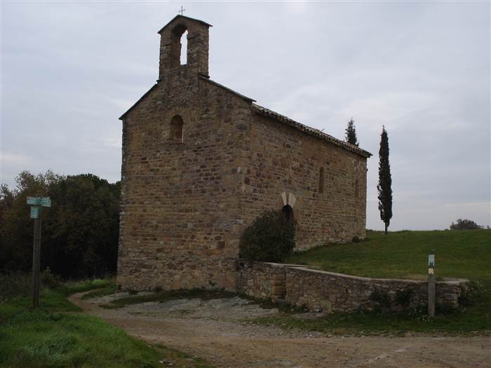
4h 00min. Monastery of Sant Pere de Casserres. We will reach the monastery after crossing a stone bridge with a mild rise .
 Total distance: 20, 055 km
Signals: Painted circuit with yellow and white marks.


 This trail with the start and the end in the town of Taradell has been changed a few years ago with account of its first original route. It is signed and well maintained by the Hiking Center of Taradell. The route goes round the town by its east and southeast side, passing through some places of interest such as Font Gran, the Anvil, the Castle of Boix (also called Taradell Castle) and the ridge of Pi Gros. The beginning of the hike is at Font Gran, but it is recommended to go up to the church of Sant Genis to go through the sanctuary. These are sacred places which Abbot Oliba put under ecclesiastical immunity and protection, 30 steps around the consecrated churches created to protect farmers and their property from the threats and assaults of the nobles.
Starting and ending point: Font Gran of Taradell (access to Taradell from Vic can be gained by B-520 and also from Malla by BV-5306)
Distance: 14.80 km Time: 4h 05min
Overall rise: 437m
Signs: yellow and white (PR) and information panels.
Description of the route:

0h Font Gran. We will start the hike at Font Gran of Taradell. It is located behind the church of Sant Genis. Earlier this fountain was known as Font of Sant Genis. It dates from 1790 and springs water through seven metal spouts and a central stone head. We’ll go on through the town of Taradell for about 20 minutes until we reach its end where we will cross the road to go up Collada de Mansa and will take a path that rises between the road on the right and a track that goes up on the left.
 0h 30min Pedrera and Creu of Pujol. At this point we will go near an old quarry and under a cross which commemorates the death and burial place of 99 miquelets in 1822. We have to follow the PR marks without any problems until we come to a forked road.
1h 10min Forked paths. We’ll leave the main trail that continues on the left and a secondary one on the right and will take a path that rises up the Cliff of Anvil.
 1h 25min Cliff oo Anvil. It is the highest point of the entire route (846m). We’ll leave the path that passes over the range of Anvil and continue under the cliff. Just at the end of the cliff, it is worth doing a short climb to rise until the flag above us where will we see the spectacular views from that vantage point. We’ll pass through the stone of Anvil, which takes its name from the shape it has.
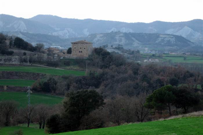
2h 10min Taradell Castle. Although the marked route bypasses the Castle it’s worth turning there. It will take us only five minutes but the views as well as the place are highly recommended to visit. To get there, the road winds between large caves and large boulders.
 2h 50min Tomb of Droughts of Gasala. This tomb is a prehistoric dolmen of 1.80 m long and 1 m wide, which is in very good condition thanks to the restoration made in 1981 by Hiker Center of Taradell. But before reaching it we will come across the drought Gasala.
3h 30min Collet Mont-Rodon. We will come over the golf course and will admire the views on the House of Mont- Rodon. It is a Gothic building renovated in 1982 and currently it is in an excellent state.
4h 05min Font Gran. Arrival at Font Gran
 Tona is the town that gives entry to Osona through the southernmost part, and this is where the trail organized by the Hiking Centre of Tona starts and ends. Enjoy a nice walk through its streets full of resorts, hotels and summer houses. Beyond the town of Tona, the PR-C43 also reveals some areas of neighboring municipalities as well as a large number of houses and fountains and we cannot ignore a monumental union, mostly Romanesque and very attractive: the chapel of Sant Michael of Vilageriu built in the twelfth century and the church of Sant Quirze and Julita of Muntanyola, the first conserved documents about which dates back to the year 938. These are two good examples.
The trail crosses the municipalities of Tona, Balenyà, Collsuspina and Muntanyola and has four derivations: l’aqüeducte, Sant Cugat of Gavadons, Cross of Miranda and the Castle of Tona. It’s also worth mentioning the shortcut or variant, which is there when we arrive at Bellavista. It takes a detour passing through Font Joana and linking back to the trail at the height of the Mill of Vendrell.
Starting and ending point: Church Square of Tona.
Distance: 23.4 km.
Time: 5 hours 15 minutes.
Overall rise: 750m
Signs: yellow and white (PR) and information panels.
Description of the route:
 0h Church Square of Tona. We leave the church square of Tona, opposite the monument of Sardana. Right there we will find an information panel of the PR-C43. We walk a bit through the town and pass Ca l’Agnès and shortly afterwards we will approach Font of Sorell, which will be in about 100m.
0h 30min Chapel of Sant Michael of Vilageriu. We’ll reach the chapel through a pine forest. From there, the land on which we walk will start changing: track, trail, until we find the bridge that crosses the road of Vic-Tona-Collsuspina. We’ll cross the road and a steep soil track will lead us to the farmhouse of Coll d’Arnau.
 1h 10min Farmhouse Coll d’Arnau. From here we’ll have the view on the plain of Vic and southern Osona. We will pass through Font of Boldrons and Can Regas, where at about 100 meters we will find a fountain that is considered the beginning of the river Besos. Having climbed to the top, the harderst trail and a path through the shady area in the forest will lead us to the crossing of Sant Cugat of Gavadons.
1h 50min Crossing of Sant Cugat Gavadons. We’ll find ourselves at the highest point of the trail at 1028m (to reach the church of Sant Cugat of Gavadons, a Romanesque building dating from the twelfth century, we can go up a path for about 5 minutes). We’ll follow the path passing Subirana house, which is currently in ruins, through the housing estate of Muntanyola, the farmhouse of Vilavendrell, the torrent of Saborit and Serrarica house, until we find a new road to Santa Eulalia of Muntanyola. Then we’ll see a turn which goes up the margin and a path that will lead us to the road to get to the church of Sant Quirze of Muntanyola.
 3h 20min Church of Sant Quirze of Muntanyola. From here, the views on the Pyrenees and the Cadi are privileged. We’ll go near the church and the cemetery to come back again to a part of the housing estate of Muntanyola. We’ll combine some paved streets with a track and, at this point, the road heads back to Tona, with its castle in the background and the path that goes down. We’ll pass Puigllat House, Bellavista House, leaving a shortcut to go to Font Joana on the right, Ros House and a small Manor Colomer and till Munter. If we want to get to the Cross of Miranda, it is about 20 minutes from Ros House.
 4h 15min The Church of Sant Esteve de Munter. The Church of Sant Esteve de Munter appears documented in the year 965. At the entrance we can see a Baroque stone frame. We’ll continue along a soil track till we cross the road of Collsuspina. We will be leaving behind such farmhouses as Can Comelles (Tona Plain), the turning of Vendrell House, the Mill of Vendrell or Puigbonic House. At this point of the path, we will be following a clear direction towards Tona to finish our excursion. But before we’ll pass the church of Lourdes.
5h 10min Church of Lourdes. The church of Lourdes of Tona was earlier called the Chapel of Santa Maria del Barrio, with the first part built in the eleventh century (the apse, the window and the bell) and the rest modified in XII and XVI century. Here, if we go up 10 minutes we’ll get to the Plain of the Castle with the Castle of Tona and the church of Sant Andreu of Lombard architecture dating from the middle of the eleventh century. Now we’ll continue walking in the town of Tona, along Vedruna school to the Church Square.
5h 15min Church Square. Monument for Sardana
 In the North of Osona, there is the Valley of Ges with the Sierra of Bellmunt as a wedge between the rivers Ter and Ges before these two come together in Torello.
With its route PR C-45 connects Torello, St. Vincent de Torello i Sant Pere de Torello through the often forgotten paths. To follow this path of about six hours of duration it is advisable to dedicate it a whole day.
It should be mentioned that among various sights in the middle of the way there is a sanctuary of Bellmunt, where you can eat comfortably.
Distance: 22,3 Km
Time: 5h 35min
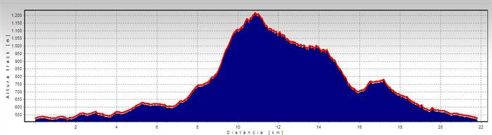 Overall rise: 950m
Signs:Yellow and white marks (PR) and information panels.
Description of the route:
 0h Square of Sardana. We leave the square of Sardana in Torello and head for Nuria Street and then on the right we’ll take the street of Espona. We’ll cross the bridge over the railway and go on the right to Pyrenees Avenue. We’ll pass in front of the railway station and continue parallel to the railway to get to the end of Progress street. Then we’ll go down to touch the road BV 5224 without entering there and turn on the left along the path of Joanet de Pujols.
0h 20min House of Joanet de Pujols. We’ll take the road that continues northward, which is outside the house, but we’ll leave it when, on the right, we find a path that runs along the edge of a field and following it, it will lead us directly to the neighborhood of Serralonga. Here we’ll find ourselves in the town of San Vicente de Torello, and along Toll street, we’ll enter the center of the village.
 0h 35min Church of Sant Vicenc. We’ll walk behind the church and go up the first alley to the Town Hall Square going along Major street, the street of the Font, and we’ll leave by Bellmunt street. Having left the town, we will run into the stream of Anijol, which we’ll have to cross and continue along the torrent of Roger for about 150 meters till we pass it through.
0h 55min Crossing with the road of Roger House. We’ll find ourselves close to the Guardia House and continue on the left along a paved road that tends to go down and we’ll leave the road when it comes up against the beginning of a small stream.
1h 20min Town of Sant Pere de Torello. We’ll cross the town by Josep Badrena street till we come to the town church. We’ll go by the eastern side of the church through a path that will leads us again to the road, which we’ll have to follow for a few meters till the first corner.
 1h 50min Chapel of San Roque. From the chapel of San Roque, the road continues on the left until Serrat House, where we will continue in the direction of hills, which will lead us to Bellmunt mountain. To reach Bellmunt we’ll go up a trail with a sharp ascent.
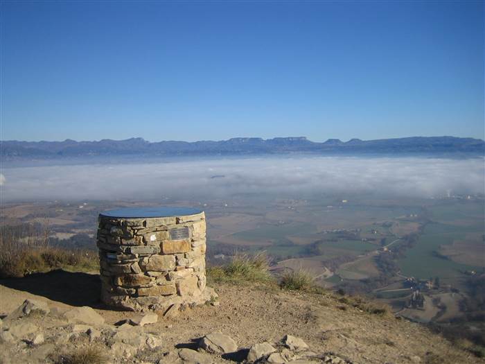
3h 05min Bellmunt Sanctuary. The sanctuary of Bellmunt is the highest point of the trail (1.256m). It is dedicated to Virgin Maria and occupies the top of the mountain, the same place where there was the Castle of Reganyada or Sa Reganyada (Serragranyada). We’ll go down by the path of Vidrà that starts from the north side of the building.
3h 20min Coll de Hiera de Massa. At this point, we will find an intersection of the trails and will leave the path of Vidrà to turn on the left by the trail of the forest track of Fages. From here, we have three quarters of an hour of a splendid beech area.
 4h Gargantes. Gorge has been created very quickly because of the erosion and is also called the Waterfall of the Witch. Then we find the Coll of Gargantes, which is also called Collet del Bosc, from the side of Torell. It was a route of woodmen and carriers between Saderra Valley and Vidra. We’ll go down the steep slope of the noon, follow the ruins of the Valleys and continue going down among fields. At the next intersection, we’ll go on the left and then on the right just before the road dies in a field. On the right, the path goes up by the base of a stirrup of a rocky and cleared mountain range, which we’ll climb up on the left without leaving its flank.
 4h 40min Occidental Collet of Maronti. We’ll follow the silhouette of the castle of Totello, which stays far from us. The Castle of Torello is located on the top of a Hill. It is the highest watchtower of the Valley, a decapitated tower is the only significant vestige that remains of the castle, dating from the year 821. Having reached the range of three Bailiffs, we’ll go down till the bottom of the gully in the direction of Vallmajor House.
5h 20min Lloriana School and Sports Center of Sant Vincenc. We are back to the town of Sant Vicenc de Torello, we’ll cross the road and take the road of Sierra, by which we’ll go out to a straight path that leads back to Torello.
 Path that follows the course of the stream of Sorreig till the sanctuary of Munts, passing through Santa Cecilia de Voltregà, Angelats, the Black Pool, Aumatell, Fosses, Sant Boi de Lluçanès and the Crown. A route through the most charming and unknown corners of the area declared PNI (Places of Natural Interest).
 Distance: 20,22 km (link river Ter – Santa Cecília, 3,5 km)
Time: 5h 30min (6h 15min from the river Ter)
Overall rise: 600 m
Description of the route:
We leave from Gallach House of Santa Cecilia de Voltregà. At this point, where the stream is crossed by the road of Santa Cecilia, the route begins leaving the stream on our left and following the poplar grove where there is Riqué House. On the other side of the river there is the Mill of Guiu. Here we cross to the other side of the stream, where there is a cement house. The course of the water forces us to cross the stream again stepping on some stones, which will facilitate the task.
 High in front of us appears Puigví House. At its feet a small stone bridge goes over a stream. On the left side and almost above there is Santa Perpetua. On the right side and very close, the cliff of the Tractor. Following this cliff we’ll find Patera del Clos, and on the other slope Sant Marti Xic and the Castle of Voltregà. At this point water of the canal of Tuta converges with that of Sorreigs. On our right, the House of Angelats. We’ll cross Sorreigs and we’ll go up following the way above us. In about 400 m we’ll cross it again and continue along a field. On our left and a bit hidden we’ll discover an old dam that stops the flow of water. Its function was to divert the flow to irrigate nearby lands.

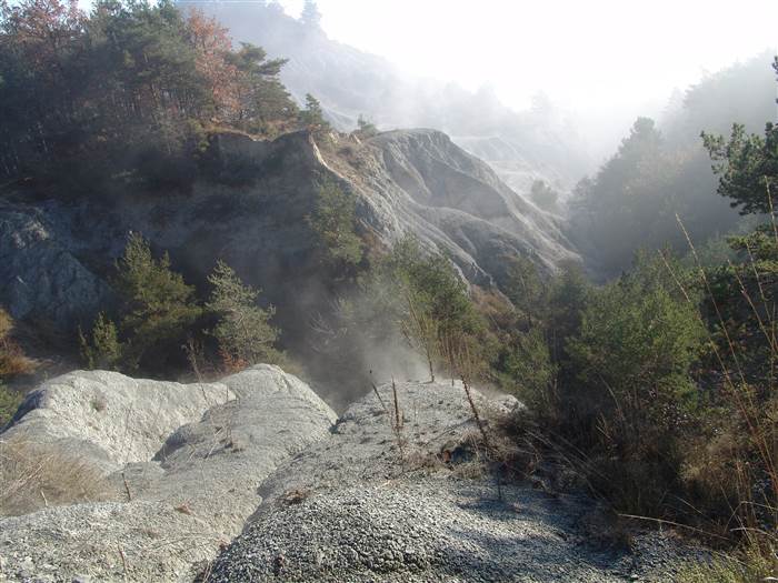
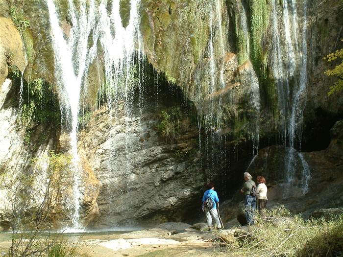
Following the usual tendency, we have to cross the river again. Now the road starts going upward and we’ll rise considerably above the level of Sorreigs. On the right of the path we’ll find a turning marked with two milestones that indicate a stop towards the Blue Gorge. Upstream from the gorge we’ll also come to the pond of the Black Gorge. During approximately 500 m the path draws a steep rocky slope. Thick vegetation of boxwood and various trees make our ascent more enjoyable. In this area the path is crossed by a stream, which during the rainy season provides the waterfall of Cabrida with water. The water hurls down the emptiness in a considerable fall.
On the right, we’ll find a path signed with orange marks that will lead up to the pond of the Black Gorge. Access is not easy because of the water spring which is there, and because of the steep slope. To follow the route, however, we shouldn’t go down. Nowadays, nothing has been preserved from that place. To have an idea, we must pay attention to the slip of the cliff, which stays in front of us, on the other side of the river. It is at this point of the path there is an esplanade, which might have been the Square of Witches. Beneath the flood it is said that there is a hole of the Black Gorge. At this point the path we follow converges with a new dirt-track that starts in Sant Bartomeu del Grau and reaches Sant Boi de Lluçanès. When we arrive at a dam, on the left bank of the river and slightly raised above the water level, we can see the old Violet House, now in ruins. Also, on the left side of the river we’ll find the caverns of Beuloví. Below these caves there can be seen an old path that went up till San Martin de Sobremunt.
 The road bends sharply before starting to go up the new track. On the left side, there appears a trail that passes drawing the profile of a cave in the middle of lush vegetation: the cave of Guiterons. We’ll follow it to the mill of Guiteres by a forest track. We’ll cross to the other side of the river in an area planted with young poplars and in about 100 m above we’ll cross it again at the height of a large rock located on the right.
An iron chain crosses the trail and a few meters further we have to change the side of the river again. Above us is the house Moli de Guiteres. A few meters down there still stand the walls of the mill surrounded by hedges. Following downstream, there’s a so called gorge of Guiterons, which makes a nice waterfall. We’ll continue going up and pass in front of the house. At this point of the road we’ll go down on the left by a path that will let a touch the water and we’ll follow along the left bank.
We’ll cross the river to cross it again in about 400 meters above, having left a junction on the left and a chain. We will arrive at the mill of Aumatell, restored and inhabited. To continue our way there we’ll pass through the middle of it till the new track and leaving the House of Aumatell in the background, we’ll turn to a poplar field that follows the canal through an idyllic landmark.
 House of Aumatell. After the poplar field we’ll follow the same bank of the river to find the forest track. 150 meters later, a small path on the left will lead us close to the river. We’ll follow it through the riparian forest. We’ll crossed the stream at the point where there is a large willow. The path goes behind the house of Puig until reaching the ring road. We’ll also leave Puig Mill, stuck in the same river and now in ruins.
We won’t arrive at the country house of Puig. The path draws a ring road and we’ll continue to Fosses, which is a large house, beautifully restored and with a chapel attached. Its mill is seen below. We’ll continue in the direction of Cornet house, although we won’t come by it. The house is on the other side and closer to the stream. We’ll also see the mill of Cornet.
We’ll cross the stream of Vilarrasa and in some meters we’ll see a well. At this point there is a junction, which we should take no notice of and continue straight towards Sant Boi de Lluçanès. On the right of the path there is a pig farm of Plans. We’ll turn left towards the ridge of Batlle. At this crossroads we’ll find ourselves in front of the municipal wastewater treatment plant of Sant Boi. In100 m above we’ll turn on the right.
 The spring well of Prada is a place of calm and relaxation surrounded by greenery. The hamlet is worth coming by. We’ll cross Sorreigs and continue through the middle of a poplar field to a bridge that allows us to cross it again. Here we leave the old path that went up to Perafita. After crossing the river again we’ll reach the mill of Perenoguera. We’ll take the beaten path in the direction of the village of Corona, crossing the river again. The turning on the left we’ll take us to farmhouse of Fontcendra. We’ll go down to the canal which then we’ll cross over it on a small bridge. Here in Sorreigs, there is a small stream that forms a gorge called the gorge of Cow. We’ll follow the poplar fields and where Sorreigs forks with the stream of Prat and of Casacuberta, we’ll continue on the right.
Following the path we’ll find the spring well of Perenoguera. From here the path is a little confusing. We have to go to a small house of the well beside the stream. We’ll get to the road of Sant Boi (BV4608), turn on the left and continue for about 200 m. On the left there is the entrance to the village of Corona. We, however, will take the path on the right, which goes up the sanctuary of Munts. We’ll follow that zig-zag path that goes up through the forest.
We’ll reach a small hill where we move closer to Munts. Following the trail, we’ll go down a few meters and turn on the left to find the asphalt road that goes up straight to the sanctuary. We are in the sanctuary of Munts, attic of Llucanes and the watchtower of the Eastern Pyrenees and Bages, Berguedà, Ripollès and Osona regions. Splendid viewpoint on Pedraforca, Montserrat, Montseny and all Transverse Range massifs.
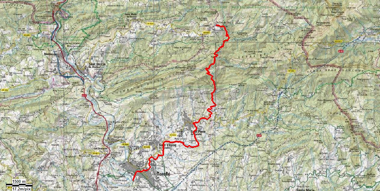 Route that follows the river Ges, linking the towns of Torello and Vidra, and passing through such emblematic sights as Fontsanta or Forat Micó where there is a small dam. It is one of the points of the capture of water, which runs through the faucets of Vic. It also takes us through the places as evocative as Tosca of Degollados, below the hill of the same name and near the hill of Hi Era de Massa, or Carlists Gorge and through places full of charm such as Mill Waterfall, the Bridge of Mill or different forests through which the route runs.
Because of the unevenness, the Path Beside-Ges has two different parts. The first part, which comes from the beginning of the route until about 4 km from Sant Pere de Torello, is rather plain rising only a few hundred meters for about 11 km, while the second part goes up to a height of 400 meters for about 7 km.
Also, due to the environ, we have two different parts that we can call the canyon of Forat Micó. Landmark of transition, where we leave behind cultivated fields and a bank forest with alders, poplars and centennial plane trees such as those of Fontsanta to penetrate, going through the canyon, in a typical environ made by some mountain pastures and beeches, living with boxwoods, ash, hazel, oaks, maples and other plant species, which we can find in other mountain environs.
 Starting point: In the sports zone in Torello, close to the confluence between rivers Ges and Ter. We will find a singal with a map from the whole path. We’ll move up the waters while crossing Torelló, firstly with the river Ges in our right and after the third point, those from Can Pujadas, we’ll move ahead with the river in our left.
Distance: 18,10 Km
Time: 3h. 50’

This route is a path that crosses the whole town of Torello, just along the river from the point of its confluence with the Ter, in the sports area, till crossing under the railway by a curious mine unfit for the tall ones. Be careful of your head.
Along the river all the time, we’ll continue upriver to the height of San Vicente de Torello, where we’ll separate a bit from the river bed to walk to the house-restaurant of Moli de Viver to follow some meters of the trail that leads to Club Tenis Torello to return to the river bank. We’ll leave the path where it crosses the river to continue upriver passing under the bridge of the road, which links San Vicente de Torello and Sant Pere de Torello, with that of Vic – Olot.
 At the height of Sant Pere de Torello we’ll leave the bank of the river again to go up till Sant Pere to go down again by the road of the Ball till reaching a central distributor of electricity from where we’ll go to look for a suspension bridge to cross the river to continue in front of the summer camp house of Moli de la Riera. From this point we’ll continue upstream to cross the river again, this time by the stone Bridge of Riera to continue on the other side, always upstream.
From here we’ll follow the river, changing from one side to the other. Having gotten to the bridge from the ground, we’ll go up on the right to cross the road of Sant Pere de Torello in the Ball following it in the direction of Sant Pere continuing a hundred meters on the right of the track that leads to Forat Micó, going further on the right from Mas la Teuleria.
 We’ll cross the river several times, always following the trail that leads to the foot of the canyon of Forat Micó, where we’ll find a very steep slope. We go through the dam of Forat Micó, one of the water catchment of the city of Vic.
Shortly afterwards we’ll leave the trail to follow a short cut, to find the track a bit further, which we will follow leaving the path of Bellmunt on the left until near the house of the Valley. Here we’ll take a path on the left going uphill towards the Torrent of Canemars, which descends from the Coll de Hi Era de Massa, finding natural curiosity of the route, Tosca Degollados, where there is a junction, at which we leave the path of Coll de Hi Era de Massa on the left.
 We’ll follow the trail a bit until we find a curve on the left, where there’s a start of a stream on the right with steep flow, from the limit of a magnificent beech area to the Mill Waterfall, where we cross the river to go up alongside the remains of the Mill Waterfall till the top of the waterfall. Then we will find the fantastic Romanesque bridge of the Mill in some meters upstream of the Gorge of Carlins.
Having crossed the bridge, we’ll take a path on the right that goes down to touch the water. To continue a bit further along the river till reaching a point where we will cross over some stones to go up on the right to look for a path, by which we will continue on the left till changing it for a path on the left indicated by a post with different signs.
This trail leads directly to the entrance of the campsite of Vidra and following a few meters more we’ll find ourselves in the foot of the monumental Oak of Creu de l’Arç, where the route ends.

The path of Oris is located at the foot of the massif of Munts, guarded by the castle of Oris at the northern end of the plain of Vic, where the territories of Ripollès, Lluçanès and Osona collide. Formerly it was a strategic zone of communication route because the river Ter crossed the area from north to south and is next to the road Ceretana.
Starting point: Nova Square in Les Masies de Voltregà (Vinyoles). From Vic we are taking the road C-17 direction Ripoll to the exit 72, km 72. From here follow the signs of Masies de Voltregà- Vinyoles which lead us to the town centre.
Distance: 22,16 Km
 Time: 5h
Description of the route:
.jpg) 0h00 Vinyoles, the New Square. We leave the village following the signs of PR (yellow and white) to enter a forest area until we cross the road of Oris which we’ll follow parallel till crossing it again before the hill of Lladrera. The road will lead us directly to the Square of Sant Genis. (Here we can approach the castle of Oris by a path on the right before reaching the square).
0h00 Vinyoles, the New Square. We leave the village following the signs of PR (yellow and white) to enter a forest area until we cross the road of Oris which we’ll follow parallel till crossing it again before the hill of Lladrera. The road will lead us directly to the Square of Sant Genis. (Here we can approach the castle of Oris by a path on the right before reaching the square).
1h00 Sant Genis. We’ll set off from the square of Sant Genís by a downhill track on the left. At this point we have to be careful since we are in a zone with little signing. Before reaching the House of Coma we’ll take a path that is on the right and leads through the grass fields with quite high grass depending on the time of year until we reach Puiglafont. From here we’ll find ourselves in a field of “go up and down” between steep slopes, which give us stunning views on both the castle of Oris and the Plain of Vic. This trail leaves us at the paved stretch that leads to the ruins of Palancs de la Noguereda where we take the path again.
1h45 Palancs de la Noguereda. We’ll take a dirt path that leads to a trough which we’ll leave on the right after passing among wooden doors and some wires. From this point, we’ll start going up steeply.
 2h00 Obaga de Vilanova, This is a crossing point of the trail. Here we can choose by which route we’ll go up to San Salvador de Bellver, the highest point of the trail, or whether we take a shorter option to Vinyoles (all options will return us to this point in order to be able to continue). We follow the trail up on the right to take one on the left further, which will become a path in the middle of the forest and will lead us to San Salvador de Bellver at 952 m.
2h40 San Salvador de Bellver. We’ll go down the cliffs of San Salvador, a path through the forest until we come to a crossroads where we can choose to follow through the forest or along the cliff path (both options are good, one is longer than the other, further they come back together in Coma de les Dues Balmes). We’ll take the short one. The path is changing types of soil and the height of slope always following through the forest with clearings which give us beautiful views on the stream of Talamanca. We will go along the path of Salta Joana passing close to the hole of the spring of Donzelles where we can go down and return to the path despite the fact it’s not well signed from this point. We’ll also pass the cliff of Swarms (here we’ll find the deviation to the spring of Donzelles and to the cliffs of Noon).
 3h30 Clot del Forn. In the middle of the forest we find an old lime kiln which indicates that we are reaching the end of the forest. We return to l’Obaga de Vilanova, a crossing of the path, which we found before getting to Sant Sebastià, and continue on the right in the direction of Creu and Vinyoles. From here the landscape and terrain change completely. We have lost altitude and we leave the trail in the forest.
4h00 Creu. We exchange tracks, footpaths, crossings and small paved sections where we have to be careful because of few and not noticeable signs in this part of the trail. We cross by the path of Rector, which links with GR3, but we turn on the left. We continue by track and turnings while continuing losing altitude till arriving again, after crossing the stream, at the beginning of the trail.
4h45 Vinyoles. We arrive at Vinyoles by a path going through fields and farms, which leaves us in the center of the village.
Start and end point: Church of Santa Eugènia de Berga
Distance: 13.2 km
Duration: 3 hours
Route: Download it
Description of the route:
0 m – Start point: Church of Santa Eugènia de Berga.
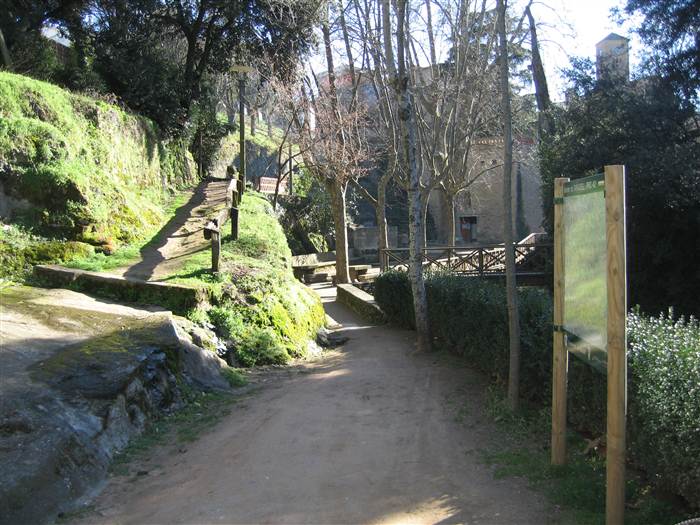
The start point is the Romanesque Church of Santa Eugènia de Berga, which stands in the centre of the village. To the rear of the church there’s a path where the route begins. It takes you past the Rodona (Round) Fountain, along a walkway that crosses the Santa Eugènia Intermittent Stream and ends up on Carrer Cadí on the Creu del Cim residential estate.
300 m – Crossroads of Carrer Cadí
You continue northwards to the end of Carrer Cadí, where you find a bridle path that leads to a set of farm buildings.
600 m – Crossroads of Comas Farms
Here you take the right turning along a bridle path from which the old brickyard can be seen.
800 m – Crossroads of the Aymerich Brickyard
You continue along a bridle path to the right without crossing the intermittent stream.
1.3 km – Crossroads of the Aymerich Tile Factory.
The first of the two houses is Cal Teuler, where bricks were made from the 12th century until 1950, when the brickyard was built and the forge was closed. You take the asphalted path that climbs up to the cemetery.
1.6 km – Cemetery of Santa Eugènia de Berga
1.7 km – Crossroads of the camí ral (ancient highroad) from Vic to Viladrau.
Once you pass the cemetery, you leave the bridle path and switch to a track on your left, which will take you to the Sala-d’Heures forest, home to the oak trees and boxwood trees typical of the Vic Plain.
2.1 km – Paradís Fountain
2.5 km – Sala d’Heures Reservoir.
You reach the Sala d’Heures Plain, located next to the reservoir that collects the water of the Vilalleons Intermittent Stream and which carried water from a canal to the Sala d’Heures manor house. You cross the dam of the reservoir and continue upwards along the path.
2.8 km – Crossroads of the camí ral (ancient highroad) from Vilalleons to Vic-Taradell.
From this crossroads you can see the Sala d’Heures manor house located 200 metres away on the left. At the crossroads you turn left onto the camí ral in the direction of Vilalleons.
2.9 km – Crossroads
100 m further on from the previous crossroads, you continue along a path on your left.
3.4 km – Crossroads
You skirt around the field continuing along the right.
4 km – Mas d’en Llopart farmhouse
Start of the route of the Vilatorta Airfield. Shelter of the Airforce Staff Committee.
4.6 km – L’Omeda.
Underground shelter of the Spanish Civil War. At this point you leave the bridle path and take the asphalted path.
4.7 km – Crossroads of the Sant Marc Path – Carretera de La Mata (road)
You head in the direction of Sant Marc, passing by Can Discorra (18th – 19th century), a house with a distinctive round water cistern.
5.7 km – Sant Marc
The earliest records of the chapel date from 1535. It was built on the boundary of the parishes of Santa Eugènia and Sant Martí de Riudeperes. To the left of the chapel there’s a monument dedicated to the naturalist Fèlix Rodríguez de la Fuente, who was a very well-known figure on Spanish television for his nature programmes.
You continue downwards along the path towards Calldetenes.
6.8 km – Crossroads of the camí ral (ancient highroad) from Vic to Viladrau.
At this point, instead of entering Calldetenes, you continue along the bridle path that goes past the Can Co and Can Cruselles houses.
7.8 km – Mas Mitjà
You pass behind the Mas Mitjà farmhouse, where there’s a chapel annexed to the house.
8.1 km – Crossroads of the road from Vic to Santa Eugènia.
You continue along a path that starts between the new houses of Isern and is then surrounded by fields.
8.6 km – Can Serrahima
Once you pass this house, you cross the Gurri River and continue left along the riverside path.
9 km – El Mercer.
Once you pass El Mercer you cross the river again.
9.7 km – Crossroads of Els Frares Spring.
At this crossroads you continue straight on.
10 km – You cross the river at the Benages Meanders
Once you cross the river, you cross the camí ral (ancient highroad) from Tona to Vic and continue along the asphalted path to the right of the Gurri River.
10.6 km – Cal Rei
10.8 km – Can Baixeres
Once you pass this farmhouse, you cross the Gurri River, leaving it behind.
11 km – Can Coll
At this crossroads you head along the bridle path on the left that is surrounded by an estate where trees are grown.
11.2 km – Crossroads of the Taradell camí ral (ancient highroad).
Once you reach the asphalted path again, you turn right onto the bridle path.
12.1 km – Hostalet del Bulló
You reach an asphalted path that you cross, passing alongside a house called Hostalet del Bulló, named after an old inn and food shop that once stood here. It was the first shop in Santa Eugènia de Berga. You take the path surrounded by woodland and terraces in the direction of the football pitch.
12.7 km – Sports area.
You take the concrete path on the right.
13.1 km – Road from Vic to Taradell
You cross the road heading towards the village centre.
13.2 km – Romanesque church.
End point
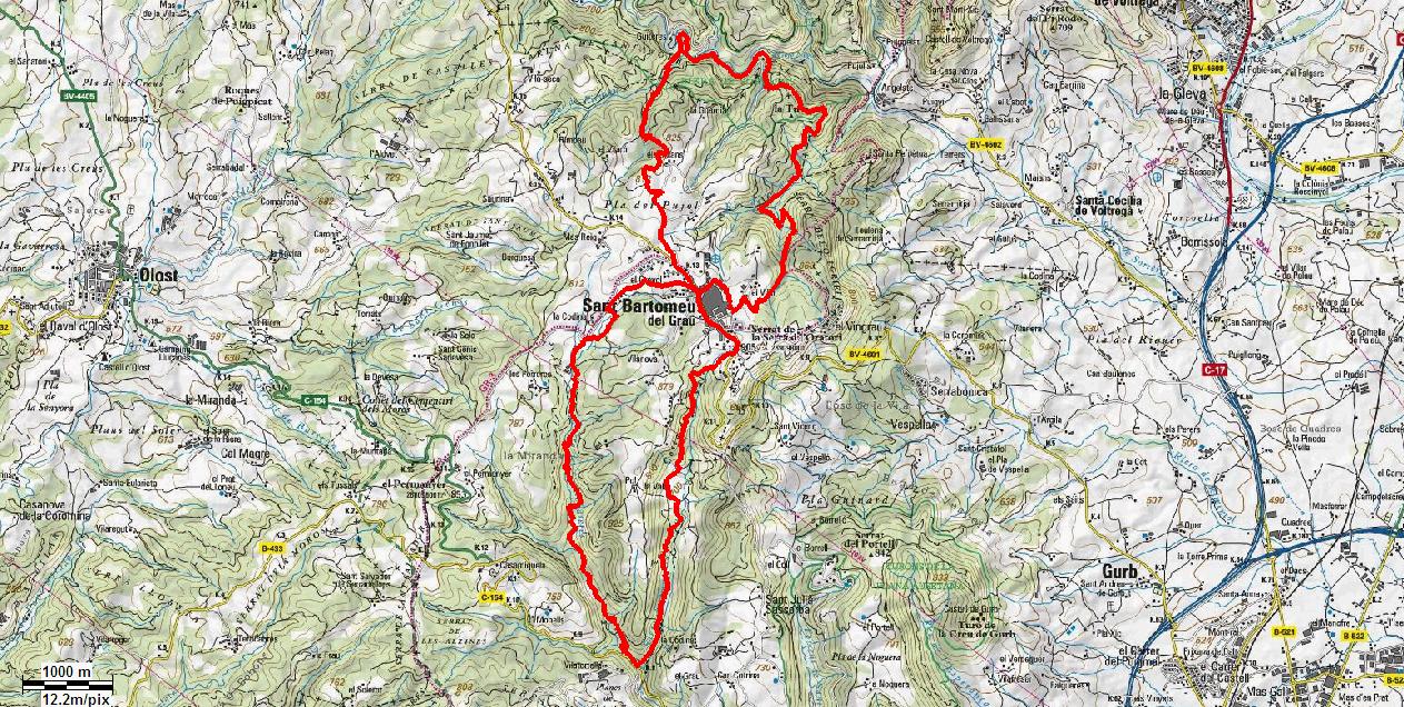
The Streams Route is a short circular route on which you can explore much of the municipal district of Sant Bartomeu del Grau. In the form of an “8”, split into two sections, it takes you along paths, tracks and trails in good condition. It’s a delightful route in a mostly low-lying area, offering plenty of shade, mainly along winding forest paths and trails.
Profile northern section

Profile southern section

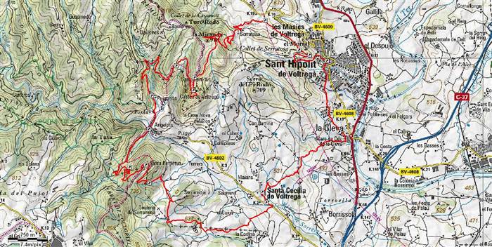 The Path of Voltregà (PR C-49) was a project prepared by the Group of Paths of Voltregà, the group which still takes care of its maintenance and conservation. The trail passes through a transition zone between the plain of Vic and the plateau of Llucanes. It is situated in the north of Osona region in a central-western position and in the east it’s limited by the River Ter.
It is an abrupt and secluded zone with thick and dense forest areas where we have to be careful to follow the well-signed paths. The higher areas have been eroded forming cliffs that shape uphill platforms, like the one of Sant Marti Xic which characterize the relief of this beautiful landmark.
The route starts from Sant Hipolit de Voltregà, passes the Houses of Voltregà – Gleva, Santa Cecilia de Voltregà. One of the most interesting points of the excursion is the chapel of Sant Marti Xic and the Castle of Voltregà, beautifully restored and preserved environ by the Association of Friends of Sant Marti Xic.
Distance: 25,31 Km
 Time: 5h. 25’
Overall rise: 1099 m
Description of the route:
 0 0 km h. Sant Hipòlit de Voltregà 532 m. We leave the church square in the direction of the New Square, the Street of Hospital and Sant Marti Street where, at the end, there is an old path leading to Santa Llúcia.
0’80 0’15 km h. Cross of Morral 636 m. Face of the rock that forms a balcony on Sant Hipòlit.
6’61 1’33 km h. Hill San Martin 849 m. The path leads us to the cliff edge and makes us go up the ridge. We are at the end of the range of Sobremunt.
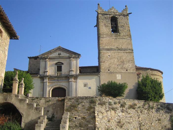
 6’69 1’38 km h. Sant Martí Xic 850 m. Castle of Voltregà. Historic ninth century estate situated at the end of the range of Sobremunt and where Voltreganès rises from. The Romanesque church is of the eleventh century and is located beneath the Hill of the Castle in a narrow ridge lined with cliffs on either side.
7’18 1’43 km h. Morrollong 840 m. We are almost at the end of the range of Sobremunt, on Morrollong, a privileged point to observe the Plain of Vic.
14’58 3’25 km h. Santa Perpetua 790 m. The path leads to the front of the chapel and having gone around it we’ll begin the descent till the house of Forat.
 20’26 4’36 km h. Santa Cecilia de Voltregà 510 m. We pass a short stretch of the road to turn on the left and to pass in front of the church.
23’51 5’09 km h. Sanctuary of Gleva 480 m. Sanctuary Maria and a small village of the Farmhouses of Voltregà. We go by Palmerola Street that links the old road leading to Sant Hipòlit de Voltregà.
25’31 5’25 km h. Sant Hipòlit of Voltregà 532 m. We’ll enter Sant Hipòlit by an old road, streets and squares built next to it.
Variant path of Voltregà: PR C 49-1.
 0 0 km h. Castle Voltregà 850 m. In the southern part of the castle of Voltregà, when the path goes close to the hill; there starts the variant PR C 49-1 that links the route of PR from here till the middle of the path of Sant Hipòlit and Gleva.
4’800 km 1.15 h. Cross of the Palace 524 m. End of the variant. We arrive at a track alongside some farms where we connect with the PR which on the right leads to Gleva and on the left to Sant Hipòlit.


tornar enrere